In the Upper Magdalena region of the department of Huila, to the very location where Colombia’s most famous river traces its source and nestled between the central and easterly ridges of the Andes Mountains is the San Agustín Archaeological Park. Here in this mountainous setting is one of Colombia’s most important archaeological reserves declared an UNESCO World Heritage Site in 1995. This region was inhabited by a mysterious and enigmatic civilization that created fantastic sculptures using the volcanic rock from which to fashion their art which over the years has taken on an otherworldly and almost immortal form.
Approximately 5000 years ago one of the oldest cultures in Latin America arrived here. Their name remains unknown and their subsequent disappearance, centuries prior to the arrival of the Spanish, is a mystery but there are various theories including that of extra-terrestrial interference. The archaeological park is found on the outskirts of the town and at an altitude of 1695m. The name San Agustín comes from two possible sources, the first being from the presence of Augustinian missionaries who arrived in this region around the year 1600 and the second relates to the memory of Santo Obispo Fray Agustín de la Coruña who passed through this area became concerned by how the abusive local ‘encomenderos’ (messengers) were treating the local indigenous populations, took up the noble cause of defending them. His activities did not make him a popular figure and he had to go into exile.
The climate here is fresh and comfortable during the daytime usually around 18ºC and at night and early morning the temperature can drop quite substantially to between 10 and 12ºC.
The wettest months are April, June and October and the driest are January, February, March, September and December. The park covers a total area of approximately 500 square km that includes San Agustín archaeological park and nearby Alto de los Idolos and Alto de las Piedras.
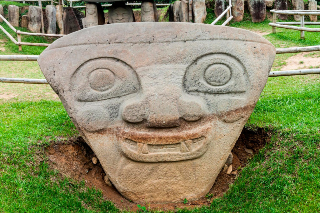
The communities that inhabited the area now referred to as San Agustín 5000 years ago were master sculptors, designing and erecting enormous, imposing stone statues and moving them to higher sacred ground. Here these statues stand today in the forms of pumas, snakes, eagles consuming snakes, warriors, good and evil and women in childbirth all looking on, as if silently watching over us. Some of the statues were found on their actual location and others have been moved in order to protect them but they remain as they were with their intricate details defying the rigours of time and still visible for all to see.
As one visits the 130 odd statues located in the park the silence that is hollow yet deafening, as if emphasizing the importance and sanctity of this place, at times is broken only by birds in song. These birds that abound in the hillsides here are the actual masters of this land only fleetingly populated by man. There is an Archaeological Museum at the entrance to the park which has a small but tidy exhibition of statues, ceramics, utensils and jewellery related to the cultures that once inhabited these special lands.
Travelling on seven hours from San Agustín is another archaeological attraction called Tierradentro which is found half way up a mountain at an altitude slightly greater than 1750m above sea level. If San Agustín is known primarily for its striking statues, then Tierradentro is famous for its burial chambers. Archaeologists state that only 100 tombs of the type found here in Tierradentro have been found in the whole of Latin America. This location has also been declared as a UNESCO World Heritage Site in particular for these subterranean funeral galleries that are extensive and must have been created by indigenous cultures inhabiting the region between the years 600AD and 900BC.
In the same department of Huila, about 42km from the city of Neiva, is the Tatacoa Desert sometimes known as the Valley of Sadness. Given its name by the conquistador Gonzalo Jiménez de Quesada in 1538, “Tatacoa” means black “rattle“ or rattlesnake, a harmless local reptile of the Tatacoa.
During the pre-Columbian era this area was inhabited by the Totoyoe Indians who were allied with the Doches and Pijaos and they all shared this dry terrain with turtles, rodents, snakes, spiders, scorpions, eagles, lizards and ocelots. These animals have thrived here finding ample places to hide here in the arid earth and between the cacti plants that grow up to four or five meters in height. This semi-arid land is referred to by biologists as a tropical dry forest and its average temperature is around 27 ºC and it is located within the fertile floodplains of the Magdalena River. The climate is hot and dry and there are a large variety of cacti that grow up out of the red earth in an area called “Cuzco” while in another area called “Los Hoyos” the landscape alters drastically and there are no longer rocks but sandy yellow dunes.
©2025 Colombian Journeys All rights reserved